
Not only is this post a day late because I was at a hockey tournament all day yesterday, but it’s another recycled post from the defunct blog, since I just got back from Florida and my work life is insane. I promise to be more original next time.
*******
This week I am shoving aside my usual angst to delve into one of my favorite subjects: research. I read and write historicals partly because I am fascinated by history. I was a terrible history student, however, because I was hopeless at remembering dates. Instead, I would get into the story–what did they eat, what kinds of houses did they live in, what did they speak, who were they?
Given this interest, it probably comes as no surprise that I am obsessed with Ancestry.com. I have used it and other sources to trace one branch of my family tree back to the Norman Invasion, and possibly beyond, although when you go back that far you have to take everything you read with a fairly large grain of salt. In exploring that branch, I came across the website of The National Archives of the United Kingdom, and on a whim, I entered some names into the search engine. I found a story from the early 15th century involving kidnapping, forced marriage (of a 9 year old!), theft and political intrigue, all featuring one of my esteemed–ahem–ancestors at center stage. It’s so captivating that despite my utter lack of previous interest in the medieval period I am itching to tell it. Eventually.
In the meantime, I wanted to share some of my research with you. If you are interested in British genealogy or inclined to write historical fiction set in Britain, there is a wealth of information (and possibly inspiration) here. If you’re not, it’s just fun to spend some time exploring. I thought I would start with places, and will discuss other sources in future posts.
Maps
I love maps. I read them for fun, and I wish I had more wall space in my office so I could hang more of them. Here are some great sources for historical maps:
Maps and more maps from 1300 to 1922.
The Gough Map of Great Britain (also known as The Bodleian Map) is the oldest surviving road map of Britain, dating from around 1360. The map itself is extremely hard to read, but it is being deciphered by researchers at Oxford University, and thankfully they have put their work online for the rest of us.
Medieval Maps of England and Europe
Greenwood’s Map of London, 1827.
http://www.old-maps.co.uk/maps.html is a fabulous source of maps you can purchase, dating from 1843 to 1996.
http://www.metaldetectorshop.co.uk/shopping_cart/index.php/maps/c_65.html has reasonably priced maps for purchase, from the Victorian period. They also have maps of Roman Britain. They do not, apparently, ship to the United States, although I haven’t yet tried begging.
John Snow’s map of London from 1859
The Booth Poverty Maps of London from 1898/99, with a modern map of London for comparison. This site is truly fascinating; it gives you a wonderful feel of neighborhoods and their character.
The National Archives purports to have over 6 million maps in its collection.
Another great source for maps is British History Online.
(Credit for links to the Victorian maps goes to Beth Henderson, who teaches an online workshop on Victorian and Edwardian history, as well as many others. If you ever get a chance to take one of her classes, do!)
One last thing, added since I wrote the original post: The Time Travel Explorer app has several different maps of London–1682, 1746, 1799, 1830, 1862, and the present. It currently also have New York maps from 1811, 1836, and 1867. It’s a bit pricey, but the coolness factor makes it worth every penny.
One last thing, added since I wrote the original post: The Time Travel Explorer app has several different maps of London–1682, 1746, 1799, 1830, 1862, and the present. It currently also have New York maps from 1811, 1836, and 1867. It’s a bit pricey, but the coolness factor makes it worth every penny.
Images of Places
I covered some historic homes in another post (I thought about including them in this one, but it got really long), but here are some sources for photos and other images of historic places:
The National Trust is a great source for information on historic places, especially if you have the good fortune to be able to visit them in person. They also have links to quirky things that might make interesting additions to a novel, like walks with ancient trees and “silly walks” featuring places with crazy names, including the “Kiss me Arse steps” in Cornwall.
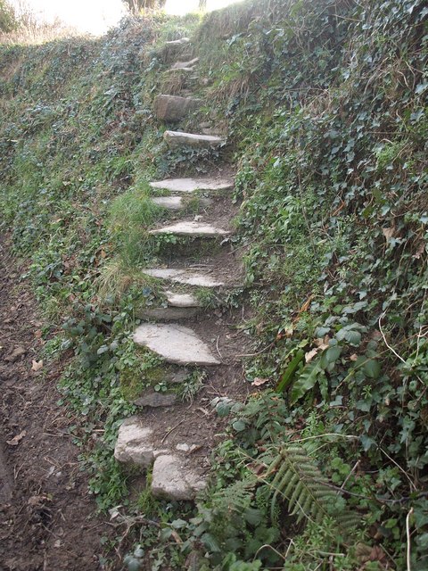 |
| Kiss Me Arse Steps, Cornwall. Copyright Derek Harper and licensed for reuse under this Creative Commons license. |
Another interesting site to browse is Geograph Britain and Ireland, which aims eventually to have photographs of every grid square of Britain and Ireland. A lot of them are remarkably unattractive photos of highway overpasses, but there are a few historic gems too.
The English Heritage website has hundreds of thousands of photographs of English places, including detailed architectural photos and some period photos from the 1850s.
Naturally over the last few centuries the names of places have changed. A good resource is the Oxford Dictionary of British Place Names, by Anthony David Mills (Oxford University Press, 2003). (There is also a Cambridge Dictionary of English Place-Names, published in 2011, if you prefer that august institution.)
There is an astonishing amount of information available, once you start looking. And so I leave you with one of my favorite places in Britain to inspire you:
 |
| Durham Cathedral. Source: freefoto.com. |
Until next time, happy exploring.
Marin